


PILBARA, Western Australia — Residents across Western Australia’s Pilbara coast have been told to take immediate shelter as Tropical Cyclone Mitchell intensifies into a severe Category 3 storm, heading toward landfall with destructive winds, torrential rain and flash flooding risks. Emergency services have issued blanket warnings from Whim Creek to Onslow, declaring it too late to evacuate and urging communities to stay indoors as the cyclone approaches.
Cyclone Mitchell Intensifies and Looms Large Over Pilbara
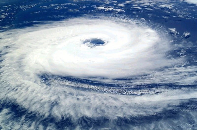
Tropical Cyclone Mitchell — which the Bureau of Meteorology (BoM) now classifies as a Category 3 severe system — has been tracking slowly southwest along the Pilbara coast, gathering strength as it nears the mainland. Authorities say the destructive core of the storm is forecast to make landfall between Onslow and Exmouth late Sunday or early Monday.
Residents have been warned to expect damaging to destructive wind gusts of up to 200 km/h or more, heavy rainfall, abnormally high tides and dangerous storm surge. Technical advisories from the BoM indicate that gusts along parts of the coast could exceed 185 km/h, with significant rain totals likely to lead to flash flooding, particularly in low-lying areas.
Emergency Warnings Issued — “Shelter Indoors Now”
Emergency WA and DFES (Department of Fire and Emergency Services) have issued an Emergency Warning covering a large stretch of the Pilbara region for residents to shelter indoors immediately. Authorities stressed that it is too late to leave coastal communities, and that the priority now is to prepare homes and secure safety zones.
The warning, displayed across alerts and emergency broadcasts, emphasises the threat to life, property and infrastructure posed by Mitchell’s destructive winds and coastal inundation. Evacuation centres have been opened in towns such as Karratha and Onslow, but the primary message from emergency officials is to bunker down and follow official instructions without delay.
Communities Brace for Impact With Preparations Underway
In the days leading up to this warning, residents along the Pilbara coast have been racing to complete preparations. Locals reported sandbagging doorways, securing outdoor equipment, tying down boats and caravans, and stocking up on food, water and essential supplies. Businesses and services in the area have also shut down or prepared for closure.
Port authorities have closed major facilities including Port Hedland — the world’s largest iron ore export hub — along with other Pilbara ports, to clear boats and prevent infrastructure damage. Mining companies have evacuated non-essential staff from regional sites, reflecting the broader economic and logistical impact of the approaching storm.
Winds, Rain and Flash Flood Risks Loom Large
Meteorological forecasts show that Mitchell’s approach will bring not just strong winds but intensive rainfall along the entire stretch of the northwest coast. As a large, slow-moving system, the cyclone is capable of dumping significant rain totals, with southwestern tracking models suggesting widespread moderate to heavy rain through the weekend and into early next week.
The combination of high tides and storm surge could further elevate flood risk in coastal floodplains and estuaries, while inland areas may experience dangerous flash flooding, particularly where drainage systems are overwhelmed. Residents in inland towns and communities have also been urged to stay aware of rising water levels and local flood advisories.
Historical Context and Regional Vulnerability
Indonesia and northern Australia’s cyclone seasons frequently bring severe systems to the Pilbara coast, which is considered highly cyclone-prone. Previous cyclones — such as Cyclone Laurence in 2009 and Cyclone John in 2018 — have caused extensive damage in the region through high winds, flooding and economic disruption to mining and shipping operations. While each cyclone’s intensity and track vary, the region’s historical vulnerability underscores the importance of rigorous preparedness.
Emergency Services on High Alert
Emergency services and disaster response teams remain on high alert as the storm approaches. DFES has urged residents to keep mobile phones charged, maintain access to sanitation and power backups where possible, and stay tuned to official announcements from local councils and emergency warning channels.
Officials have emphasised the seriousness of the situation: residents must follow shelter-in-place instructions, avoid unnecessary travel, and only seek emergency help if they are in immediate danger. Vulnerable populations, including the elderly and those living in poorly fortified structures, have been encouraged to move to designated shelters or reinforce their homes.
Looking Ahead: After the Cyclone’s Passage
Even after landfall, Meteorologists warn that Tropical Cyclone Mitchell will continue to influence weather conditions inland, bringing strong winds and rain to areas well beyond the immediate coastline. As the storm system weakens in the days following landfall, emergency responses will shift toward damage assessment, infrastructure restoration and community support, particularly in regions affected by flooding and storm surge.
Authorities advise that recovery processes may take time, with power restoration, road reopening and debris clearance among the early priorities. Residents are also reminded that dangerous conditions can persist even after the worst of the weather has passed, due to falling trees, unstable structures and damaged powerlines.
7 years in the field, from local radio to digital newsrooms. Loves chasing the stories that matter to everyday Aussies – whether it’s climate, cost of living or the next big thing in tech.