


Weather Authorities Warn of Extreme Rainfall Event
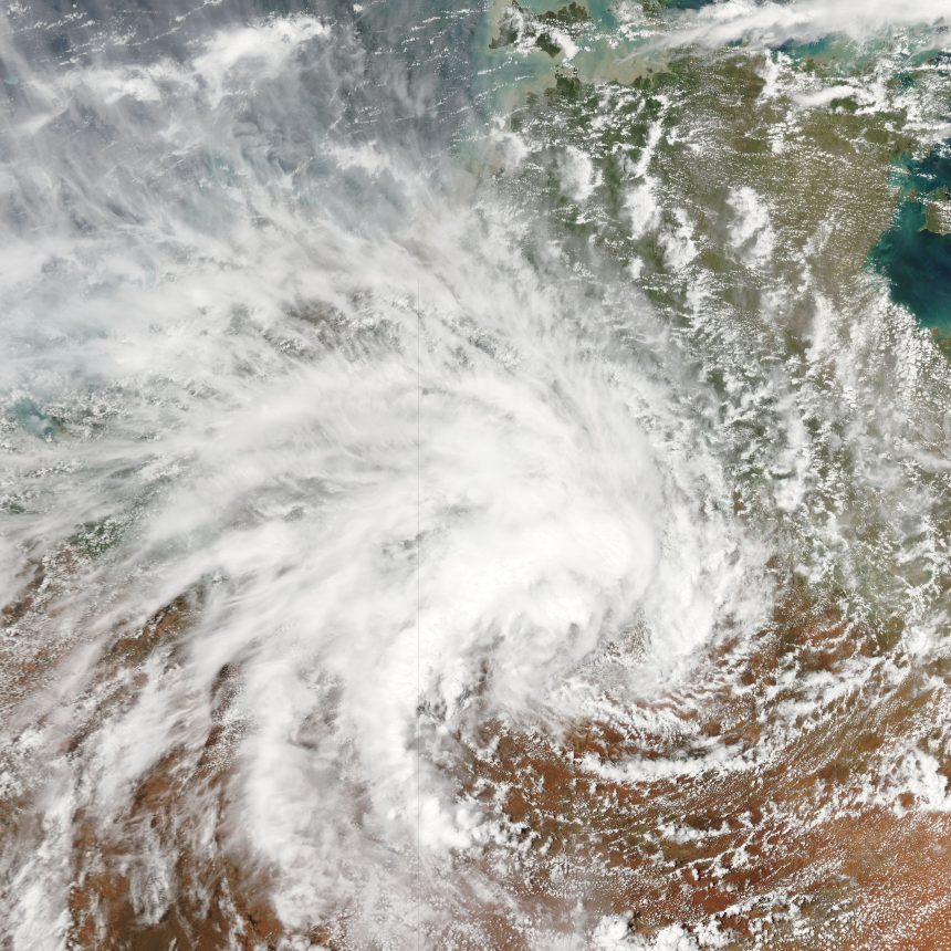
Parts of New South Wales (NSW), Queensland and South Australia (SA) are bracing for a deluge of rain as a persistent monsoon low-pressure system draws moist tropical air deep into inland and eastern Australia. The Bureau of Meteorology (BoM) has issued severe weather warnings covering large swathes of the three states, with forecasts suggesting some regions could receive the equivalent of a year’s rain in just days. The intense rain and thunderstorms are expected to develop this week and extend into the middle of the week, posing significant flood risk and widespread disruption.
The low, in combination with associated weather systems and atmospheric instability, is pulling in moisture from northern waters and combining it with other weather features such as troughs and cold fronts — sets of conditions ripe for prolonged heavy rain, thunderstorm development and flash flooding.
Rainfall Forecasts and Flood Threats
BoM predictions indicate that much of inland Australia — including northwest NSW, central and northern Queensland, and far northern and central South Australia — could see widespread rainfall totals of 100 mm to 200 mm, with some isolated areas forecast to receive 250 mm to 300 mm over the course of about a week. This magnitude of rain is equivalent to or exceeds annual rainfall averages in parts of the inland countryside.
Flash flooding, dangerous creek and river rises, and potential inundation of low-lying areas are central concerns, especially in towns such as Tibooburra, Broken Hill, Birdsville and other inland communities that have been dry for much of the summer. Additional rain bands are expected to push along the eastern seaboard, bringing showers and thunderstorms to the wider NSW and Queensland east coast late in the week.
Flood watches have also been extended to parts of South Australia, the Northern Territory and even into the southeastern states as the system progresses and deepens. Local meteorologists warn that roads, rail lines and remote communities could be isolated by floodwaters, complicating emergency responses and everyday travel.
Impact on Communities and Infrastructure
Heavy rain from monsoonal or tropical low systems often has a mixed impact. In regions long beset by drought or dry conditions, rain can replenish reservoirs, improve soil moisture and support agriculture. However, the speed and volume of rainfall forecast this week present acute risks to lives, property and infrastructure. Major roads may become impassable, flash flooding could trap motorists and trains have already been disrupted due to water-logged tracks in sections of inland Australia.
Emergency services and local councils have begun precautionary measures, including preparing flood-response resources, warning farmers to secure livestock and urging residents in at-risk zones to develop household emergency plans. The combination of heavy rain with possible strong winds and thunderstorms increases the potential for tree damage, power outages and localised urban flooding, particularly where drainage systems have been dry and untested by recent precipitation.
How This Weather System Developed
The monsoon low responsible for the forecast rainfall is part of a broader tropical weather pattern that has brought above-average humidity and rain to northern and central Australia in recent weeks. Tropical moisture from the Indian Ocean and Coral Sea has been funneled southward, setting the stage for widespread rainfall. A tropical low over central Australia continues to draw that moisture inland, encouraging thunderstorm activity and heavy downpours as the system interacts with cooler air from the south and mid-level troughs.
Climatologists note that these types of systems — including monsoonal lows and related surge events — are characteristic of summer months when tropical heating and sea surface temperatures fuel moist air masses. They can bring sharp contrasts from preceding heatwaves or dry spells to sudden and intense wet periods.
Historical Context and Extreme Weather Patterns
Australia’s inland and southeastern regions have a history of being hit by dramatic rainfall events when tropical low pressures penetrate far south across the continent. Similar systems have previously delivered seasonal breaks to drought-stricken zones while also generating flood events in Queensland and NSW. Monsoon-related rain decades ago has produced significant inland river flooding and episodic flash floods.
Scientists stress that with climate change and warming oceans, extreme rainfall events are becoming more intense and frequent, even in regions where rainfall totals were typically modest. This raises ongoing challenges for water management, disaster preparedness and infrastructure resilience across rural and urban Australia.
Preparing for Severe Weather Week Ahead
Regions under warning — including northwest NSW, central inland Queensland and northern South Australia — are urged to stay informed via the Bureau of Meteorology’s updates and flood warning services. Authorities recommend that residents living in flood-prone areas review evacuation routes, ensure emergency kits are ready, and heed alerts about rising rivers and flash flooding potential.
For many communities, the rain — though beneficial in the longer term for water supplies — may arrive much faster than the land can absorb, making proactive safety measures essential. As the monsoon low and accompanying systems continue to evolve, officials continue to monitor forecasts for any changes in intensity and rainfall distribution.
7 years in the field, from local radio to digital newsrooms. Loves chasing the stories that matter to everyday Aussies – whether it’s climate, cost of living or the next big thing in tech.