


Severe Weather Warnings Issued Across South Australia
South Australia is preparing for “highly unpredictable” weather this weekend, with authorities warning residents to be ready for heavy rain, severe storms and possible flash flooding as a tropical low system draws moisture across the region. The state’s Premier Peter Malinauskas flagged unusual weather patterns that could bring widespread rainfall and hazardous conditions to communities from the Outback to the Adelaide plains, prompting emergency services to issue alerts and update response plans.
The weather system — part of a **monsoon low pressure trough affecting much of inland South Australia, Queensland and New South Wales — is expected to deliver potentially extreme rainfall totals in some areas, with 100–200 mm possible in isolated catchments and intense thunderstorms forecast.
Flood Risks Amid Unusual Rainfall Patterns
The Bureau of Meteorology has warned that parts of South Australia could receive more rain in a few days than they would normally see in an entire year, leading to increased risk of flash flooding, rising rivers and water-logged farmland. This comes after a prolonged period of dryness in many districts, meaning the hard-baked ground may not absorb sudden deluges, exacerbating run-off and flooding hazards.
Several northern and eastern districts have already reported significant rainfall, with Port Augusta recording roughly 50 mm in a short span — notable given the area’s typically arid conditions. Severe thunderstorm and flood warnings have been issued for Flinders, Eyre Peninsula, Mid North and North East Pastoral districts, underscoring how a previously dry landscape can rapidly shift into flood risk territory.
Impact on Communities and Infrastructure
Local councils and emergency services are advising residents to secure outdoor items, prepare emergency kits and stay informed about local warnings, as severe downpours could impact roads, bridges and communication networks. Flash flooding and surface water on major highways may disrupt travel and pose challenges for rural and remote communities, as witnessed during recent rainfall events.
Authorities are particularly focused on north-western NSW and south-western Queensland where similar weather dynamics are expected — with rainfall predicted to continue into next week, raising concerns about persistent water levels in river systems that could affect South Australian catchments downstream.
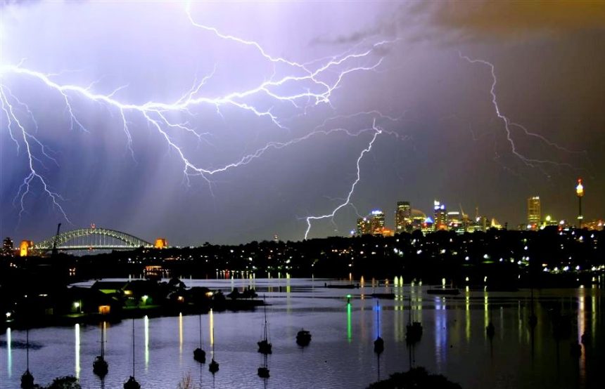
Sydney Storm Aftermath Spurs Safety Advisories
While South Australia prepares for incoming weather, Sydney and surrounding New South Wales regions are grappling with the aftermath of recent storms that brought flash flooding, road closures and widespread disruption. Sydney’s State Emergency Service (SES) has urged commuters to “take care” on the roads and public transport networks, particularly when driving through flooded areas.
The SES stressed that even after rain eases, surface water and debris can linger on streets and highways, creating hazardous conditions for cars, buses and pedestrians alike. Officials reiterated the basic safety rule: never drive, ride or walk through flood water — a warning emphasised in flood-affected parts of the city where more than 500 SES volunteers were deployed to respond to incidents of inundated homes and unstable trees.
Broader National Weather Patterns and Climate Context
Meteorologists are framing the current weather as part of a broader shift in weather patterns across southeastern Australia, influenced by a strong monsoon low drawing tropical moisture southward. These systems are becoming increasingly erratic, with heavy rainfall, cyclonic bursts and storm cells emerging unpredictably and later in the season than usual.
Experts link such variability to broader climate change trends, where warmer atmospheric conditions hold more moisture, potentially leading to heavier rainfall events and rapid storms — even in regions traditionally known for dryness or moderate weather.
Emergency Services Prepare and Advise Public
Across Australia’s southern and eastern states, emergency services are bracing for an intense weather period, urging households and businesses to stay alert, heed warnings and prepare contingency plans. Residents in flood-prone and low-lying areas are being encouraged to monitor local conditions, plan alternate travel routes and safeguard essential items against potential storm impacts.
For commuters in Sydney and throughout New South Wales, authorities emphasise that weather conditions can change rapidly, and bending to caution — such as delaying travel during peak rainfall — can make a significant difference to public safety during volatile weather.
7 years in the field, from local radio to digital newsrooms. Loves chasing the stories that matter to everyday Aussies – whether it’s climate, cost of living or the next big thing in tech.